
EPICENTRE | Could an earthquake occur in Latvia?
Geologically, Latvia lies within the interior and generally more stable part of the Eurasian Plate, meaning that the likelihood of large, damaging earthquakes is very low. The probability of potentially damaging earthquake shaking occurring over the next 50 years is below two per cent.1 This does not make earthquakes an entirely absent phenomenon. Historical accounts, seismological monitoring, earthquakes recorded in the Baltic Sea region, and traces of past earthquakes preserved in Late Glacial sediments show that Latvia’s earthquake history lies somewhere between low seismic risk and the possibility of rare but more significant shaking.2-4
The earthquake hazard in Latvia should be viewed through different layers of time. The uppermost, or contemporary, layer is characterised by low hazard, while the historical record also points to several earthquakes that were felt and, in some cases, left traces of damage to buildings. There is also a deeper geological memory. Of particular importance are seismitesA — layers found in Late Glacial sediments in the Valmiera and Rakuti areas (see Figure 1) that have been deformed by the effects of stronger earthquakes in the past. This does not mean that present-day Latvia is a seismically active region. It does, however, indicate that stronger subsurface movements have occurred in Latvia’s geological past and that earthquakes cannot be regarded as a phenomenon that can be ruled out entirely.5
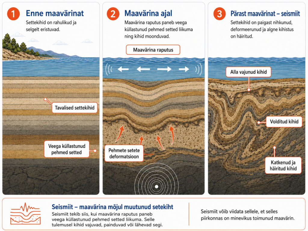
Figure 1. A seismite and its formation.
Historical earthquake memory
One of the most important sources on historical earthquakes in Latvia dates back to 1996, when the seismotectonic locations of historical earthquakes in Latvia were mapped. The dataset covers all known earthquakes from the 17th century to the beginning of the 20th century. It shows that historical earthquakes in Latvia are not distributed evenly across the country, with many associated with faults, structural zones or areas in their vicinity.6 This does not make Latvia a region of high seismicity, but it indicates that the country’s geological structure is not entirely uniform. This is also relevant information for, among other things, the development of civil protection infrastructure.
In 1616, one of the earliest known strong earthquakes in Latvia, measuring 4.8 in magnitude, occurred in the vicinity of Bauska and Valle (see Figure 2).6-7 Historical accounts mainly describe underground rumbling, shaking buildings and people being startled. Two centuries later, in 1821, several consecutive earthquakes of similar magnitude struck the Koknese area. For earlier events that were not recorded by seismographs, magnitudes have been estimated on the basis of descriptions, damage and subsequent seismological assessments. They should therefore be regarded as approximate magnitudes, as is the case with historical earthquakes elsewhere in the world.
In 1857, an earthquake occurred in the northern part of the Irbe Strait. It is considered one of the more significant events in the historical seismic memory of Latvia and the Courland coastal areas, although its magnitude did not exceed 4.8.6 Half a century later, a somewhat weaker earthquake, measuring 4.6 in magnitude, occurred in the vicinity of Daugavpils. Taken together with earlier events, these earthquakes characterise Latvia as a region of moderate and episodic seismic activity. Three features recur most often in historical accounts of such earthquakes: underground rumbling, the movement of objects and localised damage.
For a country with low seismicity, this is important knowledge. When an earthquake is a rare occurrence, its immediate impact often becomes a matter of interpretation: people hear a sound, perceive a building moving, see lamps, dishes or furniture shifting, and need a rapid explanation of what has happened.
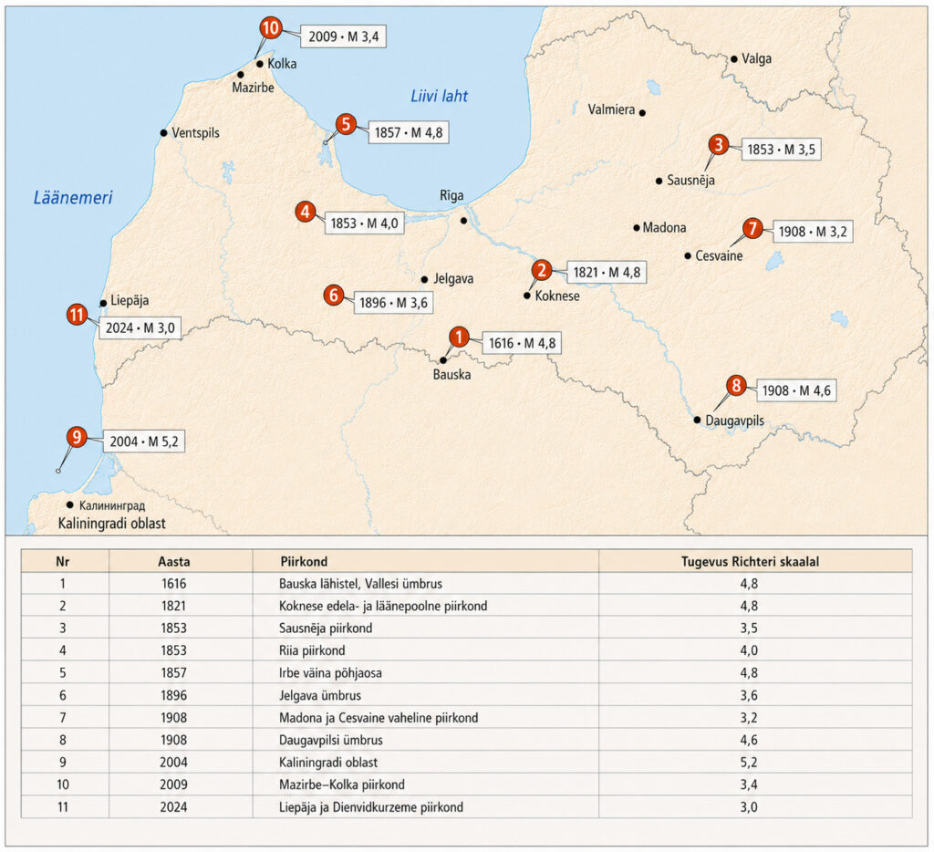
Figure 2. Major earthquakes in LatviaB
The contemporary earthquake picture
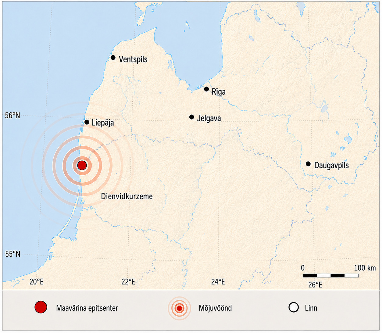
The earthquakes in Kaliningrad in 2004 (see Figure 3) are a key reference point for Latvia’s contemporary experience of earthquakes. Two strong earthquakes occurred on the same day, with magnitudes reported at approximately 5.0 and 5.2.8-9 For Latvia, the public response was also significant, as the number of calls to emergency services increased sharply because people could not immediately determine whether they were experiencing an earthquake, an explosion or another sudden event.8 The Kaliningrad earthquakes also highlighted the influence of ground conditions. For example, the shaking was felt more strongly in the Jūrmala area than in some locations closer to the epicentre because softer sediments can amplify seismic waves.2 The impact of an earthquake therefore cannot be assessed solely on the basis of its magnitude and distance. Ground conditions, groundwater, building construction and even the floor on which a person is located when an earthquake occurs also matter.
In 2009, an earthquake with a magnitude of 3.4 was recorded in the Mazirbe–Kolka area of Kurzeme. It was regarded as one of the first clearly locally generated tectonic earthquakes identified in the history of Latvian seismology.10 Its significance did not lie in major damage, but in the fact that it brought earthquakes back into Latvia’s public sphere not as a historical example, but as a local and measured phenomenon. In contrast, a weaker earthquake was recorded in the Kurzeme region in 2024 and was felt by residents of Liepāja and Dienvidkurzeme as vibrations of buildings and objects. The tremor, recorded at the Slītere monitoring station and estimated at approximately magnitude 3, highlighted a practical limitation of Latvia’s monitoring network: in the case of small earthquakes, it can be difficult to determine their exact location and magnitude quickly and unambiguously, as well as whether the event was natural or human-induced.11
Latvia’s seismological monitoring network is relatively sparse, as might be expected in a small country, and forms part of the national environmental monitoring system.12 Its role, however, extends beyond recording natural earthquakes. Modern monitoring capacity helps distinguish earthquakes from explosions and other human-generated signals, detect small local ground movements, and improve understanding of the region’s long-term seismic behaviour.4 This is particularly important in the Baltic Sea region, where a seismic signal does not necessarily indicate a natural earthquake. It may also be caused by a quarry blast, mine clearance at sea, industrial activity or another human-induced event. For example, the explosions of the Nord Stream gas pipelines in 2022, which produced seismic signals equivalent to magnitudes of 2.1 to 2.3, made this distinction a matter of security policy across the Baltic Sea region.15 Seismic monitoring is therefore no longer solely a matter of geology. It is also a matter of a state’s situational awareness and public communication capacity: can an earthquake be quickly distinguished from an explosion, and can the public be given a clear explanation of what has happened?2,4
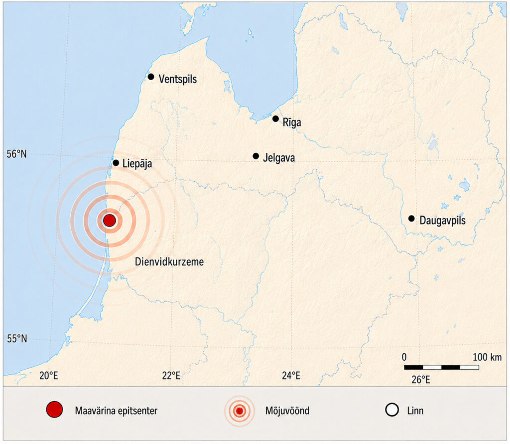
Figure 3. Epicentre of the Kurzeme earthquake
Latvia’s geological deep memory
The most intriguing part of Latvia’s earthquake history is not found in historical chronicles, but beneath the ground, where seismites have been identified in areas such as Valmiera and Rakuti. These are deformations of sediment layersC caused by earlier earthquakes.5 In both locations, the disturbed layers were found between ordinary, undeformed layers, suggesting that they were not the result of a single slow process, but of repeated sudden episodes of shaking — traces of earthquakes that occurred after the retreat of the ice sheet.5
Like Estonia, Latvia was covered by a thick layer of ice during the Ice Age, which pressed down on the Earth’s crust. As the ice melted, the land began to rise again, but this did not happen evenly everywhere. In some places, the accumulated stress may have been released through sudden movements, causing earthquakes. The deformed sediment layers found in the Valmiera and Rakuti areas are thought to point to precisely such Late Glacial earthquakes. According to the studies, these earthquakes may have reached magnitudes of up to approximately 5.0.5 This does not mean that the same conditions could recur in present-day Latvia in the same way. During the Late Glacial period, the loading of the Earth’s crust was changing rapidly and conditions differed from those today. Nevertheless, these findings are important because they show that Latvia’s geological past has not been entirely quiet. The present-day earthquake risk is low, but traces of subsurface movement are part of Latvia’s geological history.
The impact of an earthquake does not begin with magnitude alone
In Latvia’s case, it is important to distinguish between hazard and vulnerability. The hazard may be low, but vulnerability increases when buildings are old, ground conditions amplify seismic movement, the monitoring network is sparse, public information is delayed, or people do not know how to respond. The impact of an earthquake does not depend solely on how much energy is released at its source. It also depends on the earthquake’s depth, ground conditions (such as soft sediments and groundwater), the condition of buildings, and where a person is located when the earthquake occurs. For example, in the Jūrmala area, softer ground has been shown to amplify the perceived effects of the 2004 Kaliningrad earthquake.2 This is also relevant for Riga, Jūrmala and other more densely populated areas (see Figure 4), where the physical strength of an earthquake may be small, but public perception and the need for information may be significant.
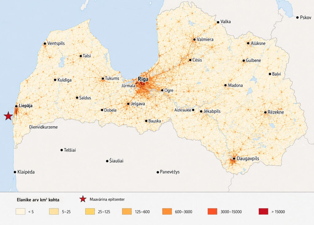
Figure 4. Population density in Latvia
Earlier discussions on seismic risk and geodynamic monitoring have also considered critical facilities such as the Pļaviņas Hydroelectric Power Station and the Inčukalns underground gas storage facility.3,13 This does not mean that these facilities face an imminent earthquake disaster. Rather, it means that in a country with low seismicity, critical infrastructure needs to take local geology, ground conditions, groundwater, structural characteristics and monitoring capacity into account. Latvia’s earthquake vulnerability lies not primarily in the prospect of a major natural disaster, but in how a rare physical disturbance intersects with the urban environment, infrastructure, the condition of buildings, monitoring and public communication. When people feel a building move and do not know what has happened, an earthquake first becomes an information crisis.
When the urban environment is shaken not by the ground, but by war
Today, Latvia’s earthquake hazard cannot be considered solely as a natural phenomenon. Russia’s aggression against Ukraine has changed the discussion on crisis preparedness across the Baltic Sea region and has also highlighted the question of how societies cope with physical destruction, collapses and service disruptions. War is not an earthquake, but high-explosive weapons used in civilian environments can produce similar patterns of damage in cities: damaged buildings, the need for evacuation, disrupted electricity, water and communications, blocked roads, and the need to rapidly assess whether buildings remain safe to use.
For Latvia, therefore, it is not only important to consider how likely a strong natural earthquake is. Equally important is preparedness for situations in which buildings are damaged, people need to be evacuated, services are disrupted and the public requires reliable information quickly. Urban search and rescue, technical assessment of buildings, temporary accommodation, assessment of critical infrastructure and clear public communication are capabilities needed in the event of an earthquake, explosion, drone attack, missile strike or major infrastructure failure alike.
In 2020, Riga’s extraordinary local elections were described as a political earthquake because they altered the balance of power in the capital and brought an end to the established long-standing political configuration.14 In geological terms, this is merely a metaphor, but in the context of crisis preparedness, the image helps illustrate how a sudden shift can expose a system’s actual resilience. A rare physical disturbance can do the same: it shows how well monitoring, public communication, emergency response, local governance and public preparedness function.
In this sense, Latvia can also be said to face an earthquake without a seismic epicentre. A crisis arising from Russia’s aggression does not begin in the Earth’s crust, but it can shake the normal functioning of society: causing collapses, disrupting services, forcing people to evacuate and requiring rapid decision-making under conditions of limited information.D This does not equate war with a natural disaster. It does, however, show that many practical capabilities overlap when managing their consequences.
What can be learned from earthquakes in Latvia?
Latvia does not need to shape its crisis preparedness on the model of countries with high seismicity, as there is no geological basis for doing so. At the same time, the country’s seismological history shows that even a rare natural phenomenon can serve as a stress test for crisis preparedness. An earthquake tests monitoring, public communication, public behaviour, building inspections, emergency response capacity, infrastructure continuity and local-level governance. In Latvia’s case, however, the challenge is not a large-scale natural disaster, but a rare and initially difficult-to-interpret disturbance. If people feel the ground move but official information is delayed or remains ambiguous, conditions are created for both rumours and the spread of disinformation. Seismic monitoring can therefore also be understood as a communication capability in a country with low earthquake risk: the state must be able to quickly explain whether an event was an earthquake, an explosion, quarrying activity or something else.
In Latvia, a large natural earthquake remains unlikely. A more realistic scenario is a rare but perceptible earthquake whose impact may be expressed not through destruction, but through public reaction, emergency calls, the need to inspect buildings, assess infrastructure and provide a rapid explanation. The same capabilities are also needed when society is affected not by movement of the Earth’s crust, but by an explosion or military attack. The question, therefore, is one of preparedness to recognise a rare hazard quickly, place it in the correct context and respond proportionately. This requires effective monitoring, clear public communication, the capacity to inspect buildings and infrastructure, urban search and rescue, prepared local authorities and basic household resilience — all of which are critically important for the development of civil protection in Latvia.
Remarks
A The German palaeontologist Adolf Seilacher first used the term in 1969 to describe features of sediment layers deformed by earthquakes.16 The term is now used more broadly: seismites may include both deformed layers and structures extending through several layers, such as sand volcanoes.17
B For historical earthquakes, the magnitudes presented in the table are retrospectively estimated values. For contemporary events, the data are more precise, although the location and magnitude of small earthquakes also depend on the density of the monitoring network. For example, the Kaliningrad earthquakes did not occur on Latvian territory, but they are important for Latvia because they were felt there and highlighted the low, but not non-existent, level of seismic risk in the Baltic region.6,8-10
C Layers that sank, became undulated or were mixed while the sediment was still soft and water-saturated.
D Both Estonia and Latvia are located in the interior of the Eurasian Plate, an area of low seismicity, but the experience of both countries shows that low risk does not mean zero risk. The 1976 Osmussaar earthquake and the experience of the 2004 Kaliningrad earthquakes are regional reminders that a rare earthquake can be felt by people, place pressure on information channels, and raise questions about the preparedness of buildings, infrastructure and public communication.6,8
Figures: earthquake maps and data visualisations (Crisis Research Centre, 2026).
🔺The use, distribution, modification or publication of this text and figures is permitted only with the prior written agreement of the NGO Crisis Research Centre. Any unauthorised use is prohibited.
Sources
2 Bekmanis, Z. 2023. Zemestrīces Latvijā – ne biežāk kā līdz šim. 16.01.2023, LA.
Jaga postitust: