EPICENTRE | How realistic is a devastating earthquake in Denmark?
Denmark is not usually associated with earthquakes. In recent years, the country’s perception of risk has been shaped more by storms, floods, power outages, cyberattacks, and, increasingly, drone-related security threats. Yet the earthquake that occurred in the Køge Bay area showed that even a seemingly calm country can move. With a magnitude of 3.9, the earthquake was rare and noticeable enough in the Danish context to raise the question: how realistic is an earthquake there that does not merely cause alarm, but also results in actual damage?
Denmark is not a seismically active country in the same sense as Italy, Japan, Turkey, or the Philippines. Major tectonic platesA do not meet there as they do in many of the world’s most dangerous earthquake zones. Denmark is located within the Eurasian Plate, in an area generally considered stable, but this does not mean that earthquakes are impossible there. Even within more stable parts of the Earth’s crust, stresses accumulate and may occasionally be released as minor or moderate earthquakes.
At the same time, Denmark’s earthquake risk is considered low in global comparison. Even in the case of a stronger earthquake, estimated to occur on average once every 475 years, ground motion in Denmark would remain relatively limited, and the largest possible natural earthquake is currently estimated at a magnitude of 5.3.¹ For this reason, a major earthquake is not treated as a separate key crisis scenario in Denmark’s national risk assessment, as its likelihood in Denmark and the surrounding area is low.² This provides a fairly precise framing of Denmark’s situation: an earthquake is a real natural phenomenon there, but based on current knowledge, a devastating major earthquake is highly unlikely.
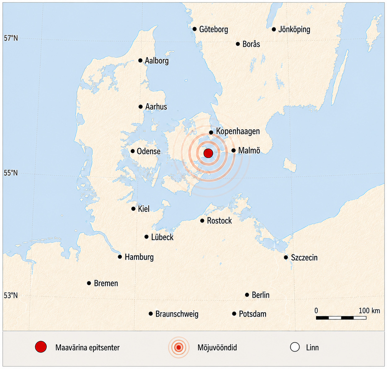
On 20 May 2026, at 16:14 local time, an earthquake occurred in the Køge Bay area, with an estimated magnitude of 3.9. The earthquake’s epicentre was located approximately 37 kilometres southwest of Copenhagen (see Figure 1), and it was recorded by all seismic stations in Denmark, as well as by stations in southern Sweden and Norway.3,4
Figure 1: The epicentre of the Køge earthquake
The societal impact of the earthquake, which caused no casualties or damage, stemmed from its location: the epicentre was close to Denmark’s most densely populated area (see Figure 2). More than one million people live in the Copenhagen area, and Køge is located in the southern part of the capital region, where daily mobility, working life, and transport connections closely link the area to Copenhagen.5,6,7 As a result, even a moderate earthquake can attract considerable attention and generate a large number of emergency calls. When an earthquake occurs in an area where people are not accustomed to such events, it also quickly becomes a matter of communication: people need to understand quickly what exactly happened and where.
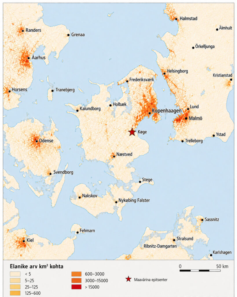
Figure 2: Population density within a 150 km radius of the epicentre
To understand the Køge earthquake, it is important to distinguish between the size of an earthquake and its impact. While magnitude describes the amount of energy released at the earthquake’s source, the impact experienced by people also depends on other factors: the depth of the earthquake, soil conditions, the condition of buildings, and where a person is located during the earthquake. Local geology can either weaken or amplify the effects of an earthquake, and under certain conditions, even a smaller earthquake can be clearly felt locally.8
In the case of the 2026 Køge Bay earthquake, people on higher floors may have felt the earthquake more strongly than those at street level.4 Therefore, the societal impact of an earthquake cannot be assessed by magnitude alone. In Denmark’s case, it is also important whether an earthquake occurs in a densely populated area and what condition the local building stock is in.
Denmark’s history indicates the possibility of local damage, not a pattern of major catastrophe
Earthquakes in Denmark are rare, but not impossible. Smaller earthquakes are recorded in the country every year, but most of them are so weak that people do not feel them, and they remain mainly visible in seismic station data.9,10 Danish earthquakes do not occur on an active plate boundary, but within a more stable part of the Earth’s crust. Even in such areas, stresses can accumulate in the crust and occasionally be released as smaller earthquakes.
The general stress field is influenced, among other factors, by the Mid-Atlantic Ridge, but the location of a specific earthquake is determined by the local structure of the Earth’s crust, old faults, and weaker zones within the crust.¹ The Sorgenfrei–Tornquist Zone in northeastern and northern Denmark is a geologically important area, but this does not mean that strong or frequent earthquakes necessarily occur there.¹¹ The distribution of earthquakes (see Figure 3) shows that in Denmark and its surrounding areas, they tend to cluster in certain regions rather than being evenly distributed across the country.
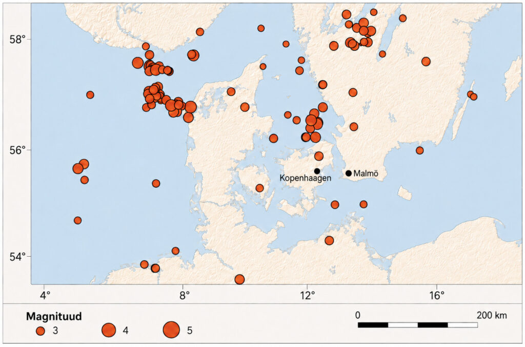
Figure 3: Earthquakes in Denmark and surrounding areas23
Earthquakes in Denmark are not distributed entirely randomly in space. Many epicentres are located offshore, particularly in the Kattegat, Skagerrak, and North Sea areas. On land, northwestern Jutland and northern and central Zealand have been more active, including the area around Roskilde Fjord and the broader Copenhagen–North Zealand–Isefjord region.8,12 In the case of historical earthquakes, however, it must be kept in mind that the exact location of older earthquakes is not always certain. Before modern digital monitoring, much of the data was based on people’s descriptions, damage reports, and later reconstructions.
More recent data are significantly more accurate: all earthquakes of at least magnitude 3.0 that have occurred on land in Denmark since 1960 have been recorded by seismic stations, and since 2000, the detection of smaller earthquakes has also improved.13 Denmark’s historical experience shows that earthquakes can cause local damage, but so far they have not indicated a realistic threat of widespread urban destruction. One of the most important earthquakes was the 1759 North Kattegat earthquake, whose magnitude has retrospectively been estimated at up to 5.6 and which has been associated with strong ground motion and damage to buildings; the best-known example is the collapse of the upper part of Budolfi Church in Aalborg.1,13
The second strongest earthquake, with a magnitude of 4.5, occurred near the coast of Thy in 1841 and also left traces on buildings, including collapsed chimneys, cracks in walls, and minor ground ruptures.13 Both earthquakes are significant in the Danish context, but their damage was limited and local, and does not resemble the destruction known from active plate-boundary regions. More recent earthquakes have followed the same pattern, although they have been weaker. For example, the 2001 Holbæk earthquake had a magnitude of 2.8, but it was felt locally, as was the 2004 Køge Bay earthquake with a magnitude of 2.9.
The 2008 Skåne earthquake in Sweden, with a magnitude of 4.8, was also felt in Denmark. Ten years later, the 3.6 magnitude Holstebro earthquake attracted attention because it occurred in an area where earthquakes were not usually expected.14 The 2026 Køge Bay earthquake also fits this pattern (see Figure 4): strong and noticeable to the public in the Danish context, but not devastating.
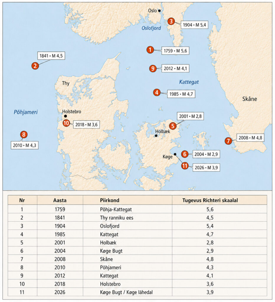
Figure 4: Major earthquakes in Denmark
Earthquake preparedness in Denmark
In Denmark’s crisis preparedness, earthquakes are not a central risk, but this does not mean that the country lacks the capacity to respond to unexpected physical incidents. Denmark’s national risk assessment focuses primarily on threats whose likelihood or impact is more significant for the country: storms, floods, infectious diseases, infrastructure disruptions, cyber incidents, and threats arising from the security environment. A major earthquake is not addressed as a separate key scenario, because such an earthquake is considered highly unlikely in Danish conditions.2
This does not mean denial, but rather the prioritisation of risks. At the same time, Denmark’s general crisis preparedness is still relevant in the event of an earthquake. Residents are advised to be prepared to manage independently for at least three days. Such preparedness is not intended for one specific threat only, but helps people cope with different disruptions: temporary interruptions to electricity, water, communications, transport, or services.15 A moderate earthquake, including one caused by the explosion of a ballistic missile or glide bomb, may also create the need to inspect buildings, temporarily close some streets, reassure people, or resolve disruptions. For this reason, general household resilience is sensible even when an earthquake is not the primary risk.
One of Denmark’s strengths is also seismic monitoring, which also uses data from neighbouring countries and, when necessary, helps refine the location, depth, and magnitude of earthquakes.9,10 Such a system is necessary not only for earthquakes, but also for clarifying other sudden incidents. After the Nord Stream explosions in 2022, seismic monitoring played an important role, as monitoring stations helped distinguish an explosion from an earthquake and provide information to the national operational level.16 In a country with low earthquake risk, this capability is particularly important: when the ground shakes unexpectedly, it is necessary to clarify quickly and reliably what has happened.
In terms of rescue capacity, Denmark also has experience in collapse rescue and international search and rescue operations. Exercises have included practising the search for people in collapsed buildings, and the international MODEX exercises held in Tinglev have used a strong earthquake and extensive building damage as a scenario.17-19 This does not mean that Denmark is preparing for a domestic major earthquake in the same way as countries with high seismic risk. Rather, it shows that collapse rescue skills are needed more broadly: they can be used on international assistance missions, but also in domestic situations involving explosions, building collapses, or major accidents.
Earthquakes have not been entirely disregarded in building standards either. The Danish national annex to Eurocode 8 includes the consideration of seismic loads, and under the simplified Danish alternative, the horizontal seismic load must not be taken as less than 1.5% of the vertical load.20 This shows that earthquakes are not treated as a zero-risk issue, but they do not shape Danish building practice to the same extent as in countries with high seismic hazard. The most vulnerable elements are likely to be older masonry structures, chimneys, façade elements, plaster, and other non-load-bearing parts of buildings. Historical damage confirms the same pattern: damage has been associated mainly with individual building components and the older built environment, rather than widespread building collapse.1,13 The scale of Denmark’s earthquake hazard can be better understood by comparing it with the world’s stronger earthquakes. On 8 June 2026, a magnitude 7.8 earthquake occurred in the Mindanao region of the Philippines, sadly causing many casualties and extensive destruction.21-22
Denmark’s experience shows why low risk should not be equated with non-existent risk, even when the likely impact of an event is primarily emotional and alarming. The ground can move even in an area where earthquakes are not among the usual crisis threats. The same also applies to Estonia. This does not mean that Denmark or Estonia should prepare for earthquake disasters of the kind associated with the Mediterranean region. In a country with low seismicity, the impact of an earthquake is often reflected in public reaction, the need for rapid information exchange, building inspections, and general preparedness, rather than in extensive physical destruction.
At the same time, Russia’s aggression in Ukraine has shown that high-destructive-power weapons used in civilian environments can create a damage pattern comparable to that of an earthquake in cities: damaged buildings, the need for evacuation, and a sudden disruption of everyday life. For this reason, preparedness messages directed at residents of Denmark and other Baltic Sea region countries are not linked to one specific threat alone. The region must also take into account a kind of earthquake that has no seismic epicentre: a crisis arising from aggression, which can shake society just as unexpectedly and forcefully.
For Denmark, the central question is not whether to fear an earthquake, but whether society can quickly recognise a rare threat, explain it clearly, and respond without either overestimating or underestimating it. This requires functioning monitoring, clear public communication, general civic preparedness, and the capacity to inspect and, where necessary, temporarily close damaged buildings. The broader lesson, however, is larger: crisis preparedness does not mean preparing only for the most likely threat, but also having the capacity to act when society is struck by a rare, unexpected, and initially difficult-to-understand situation.
Remarks
A A plate tectonics map helps explain why Denmark is not among the most earthquake-prone regions. Strong earthquakes are concentrated mainly along plate boundaries, while Denmark and Estonia are located in the more stable interior of the Eurasian Plate. This reduces the likelihood of a strong earthquake, but does not rule out smaller and locally perceptible earthquakes.
Figures: earthquake maps and dataset visualisations (Crisis research Centre, 2026).
🔺The use, distribution, modification, or publication of the text and figures is permitted only with the prior written agreement of NGO Crisis Research Centre; unauthorised use is not permitted.
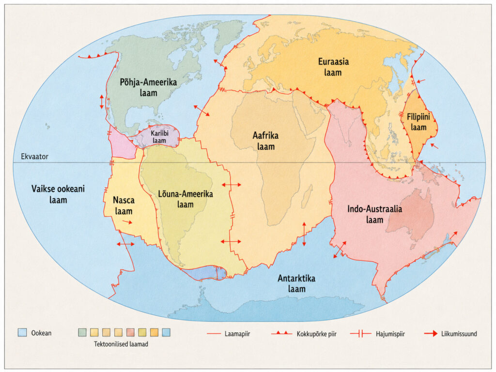
Figure 5: Tectonic plates of the world
Sources
8 Sandersen, P., Binderup, M., Larsen T.B. & Nilsson, B. 2021. Geological Survey of Denmark and Greenland. 2021. Studies of geological properties and conditions for deep disposal of radioactive waste, Denmark. Phase 1, report no. 7: Evaluation of long-term stability related to glaciations, climate and sea-level, groundwater, and earthquakes. GEUS.
16 [Anon.], 2022. GEUS overvåger for rystelser.27.09.2022, GEUS.
Jaga postitust: